Nexyad has just been rated by Early Metrics : We got Three Stars
Early Metrics, first rating agency for startups gave three stars to NEXYAD.
The audit of NEXYAD has been ordered by a major industrial company of Automotive. The founders, the project, the market and the financial statement of NEXYAD were rated 75/100.
NEXYAD is then in the 20% highest rates ever given by Early Metrics.
The Ultimate Solution for Insurance Companies that need Onboard Risk Assessment : SafetyNex
. WHY TESTED SOLUTIONS ALL FAILED (ACTUARIES SAY) ?
. WHY SOLUTIONS BASED ON « SEVERE BRAKING », « VELOCITY IN CURVE », « ACCELERATIONS » … HAVE STRICTLY NO CHANCE TO WORK ?
. WHAT TO DO TO GET A RISK ASSESSMENT MODULE THAT WORKS? (Presentation of a disruptive solution)
Obstacle Detection using ObstaNex BiCam v1.0 : Rear Vision Demo
Nexyad runs two monovision-based obstacle detection modules (ObstaNex V2.1), and developed a data fusion algorithm that reshapes stereo.
This solution still can work in monovision when one camera is off.
In this example, we installed cameras in the place of rearview Mirror on a van.
Detection of pedestrian near the vehicle
Road Detection using RoadNex on Smartphone & RT-Maps
Road Detection using Smartphone Camera (IOS, Android, Windows Phone) : Nexyad Team validated that RoadNex works in real time on smartphone !
Otherwise, a new release of Nexyad Road Detection and software module is available on RT-Maps (by Intempora). RoadNex v2.3 (32 & 64 bits).
Soon available on IOS, Android and Windows Phone.
Future Presence of Nexyad on Congresses & Exhibitions (ADAS, Autonomous Cars & Insurance)
Day 2 : April 13th1st 15:00 – Exclusive Nexyad Presentation by CEO Gérard Yahiaoui
The Ultimate Solution for Insurance Companies that need Onboard Risk Assessment : SafetyNex
Why tested solutions all failed (actuaries say) ?
Why solutions based on severe braking, velocity in curve, accelerations… have strictly no chances to work ?
What to do to get a risk assessment module that works ? (presentation of a disruptive solution)
Day 2 : June 1st 09:30 – Building a relevant validation database for camera-based ADAS Gérard Yahiaoui, President and CEO, Nexyad, France
Validation of camera-based artificial vision systems applied on open world is a very complex issue. An HD colour camera may generate more than 65 000 power 2 000 000 different images (information theory), so it is not possible to test every possible message. We propose a deterministic approach for building a validation database using the AGENDA methodology that was developed and published in the 1990s for neural network database (learn and test) design.
Nexyad will be present on a booth with Groupement ADAS. Groupement ADAS is a Team of innovative companies with over 20 years experience in the field of technologies used in driver assistance systems and autonomous vehicles (design, implementation and integration of ADAS in vehicles for safety features, driver assistance, partial delegation to the autonomous vehicle). Members of the groupements propose complementary expertise, tools and test equipment (including test tracks) to take-up your challenging projects covering vehicle electronics, vehicle dynamics, command/control, HMI, perception, computer vision, data-fusion, communication, eco-driving… Groupement ADAS members are: CAR&D , FH Electronics, GlobalSensing Technologies, Intempora, Nexyad, Nomadic Solutions, Sherpa Engineering and Transpolis. It is coordinated by the French MOV’EO cluster.
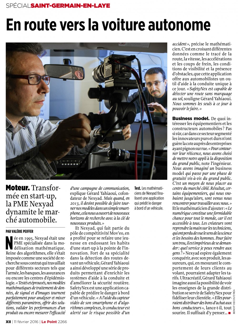
Nexyad in Media
« En route pour la voiture autonome » – On the Way to Autonomous Car
The french weekly « Le Point » on February 11th released a special section on the city of Saint Germain en Laye near Paris. The journalist Valerie Peiffer has devoted a page to Nexyad.
18 Feb 2016 :
NEXYAD president CEO Gerard YAHIAOUI, and a panel of SMEs founders were invited by Isabelle STHEMER of DojoGroup, in Paris, and could exchange points of views about economics and small business development with French Senator Claude NOUGEIN.
The main purpose was to share ideas that may enhance SMEs performance and French competitivity.
Gérard Yahiaoui in a very casual discussion.
The Senator Claude NOUGEIN (here) that dares to talk to the base for a better understanding of the micro economy in the country. Quite unusual in France and very important !
Thank you Monsieur le Senateur !
Nexyad RoadNex v2.2 is the only Road Detection module software operable in framework RT-Maps by Intempora.
It is possible to connect multiple sensors included cameras on RT-Maps, collecting data in real time and time-stampted them. Later play and replay video with all your data.
NEXYAD VisiNex Onboard v2.0 is now available on RT-Maps (by Intempora).
It comes with local Visual Quality Score (VQS) figured by colors :
Green is high, orange is medium, red is low.
See Demo film below on foggy weather condition :
NEXYAD has been starting the development of a data base for artificial vision-based ADAS test and validation.
This data base will be relevant and unique because it is fully decribed in two ways :
. reality : position of road and obstacles
. driving situation (i.e. curve in a foggy weather with pedestrian crossing, …) using the methology AGENDA.
To read more :
– « Methodology for ADAS validation: Potential Contribution of other Scientific Fields which have already answered the Same Questions »,
G. Yahiaoui, P. Da Silva Dias, proceedings of the 3rd CESA Automotive Electronics Congress May 2014 Paris, Lecture Notes in Mobility,
ENERGY CONSUMPTION AND AUTONOMOUS DRIVING, Jochen Langheim Ed, Springer, pp 133-138.
– « Validation of Advanced Driving Assistance Systems », G. Yahiaoui, N. du Lac, SafetyWeek congress, Aschaffenburg, May 2015.
Business details :
A part of this data base will be soon available for free on the internet, to the worldwide ADAS and Autonomous
vehicle community (labos and firms).
If you wish to receive the link as soon as it is available, click HERE and fill the registration form.
(Free access to the NEXYAD Artificial Vision-based ADAS Validation Database)
The complete data base should be available soon through an annual membership.
For more information : contact NEXYAD Olivier BENEL +33 139 04 13 60
* * * * *
ITS World Congress in Bordeaux
From 5 to 9 October, the ITS World Congress held in Bordeaux.
It is the world’s largest gathering on the subject of intelligent transport systems and numerous corporations and government agencies were present to discuss new technologies, communication and robotics which every day are revolutionizing commercial road transport, individual and collective.
From our point of view, three main domains distinguished themselves which are however increasingly closely intertwined: the vehicle, the infrastructure and information.
The most spectacular of them represented by the many autonomous vehicles that lined the stands or went in demo mode near the fairgrounds.
We noted a trend of convergence between the connected vehicle on one hand and adas in the other hand, all autonomous vehicles were also connected vehicles and communicating vehicles : car to x and x to car (especially radio link with fires and road signs.)
The AKKA link in city car without driver of the French IT company has rolled around the lake so the city. This electric car is the result of a call for projects from the agency for the development and innovation of the Aquitaine region and it uses open data from the city of Bordeaux and its neighbourhoods.
From Renault, we saw the Next Two a piloted car remotely by a tablet. It parked all alone with no one behind the wheel. We liked particulary that this functionality avoids a walking pedestrian crossing in front of the car. Then it returns to the starting point when you recall it, always from the tablet.
Moveo-Groupement ADAS is a cluster of 8 french SME’s that put their competence in common to develop autonomous car. They showed on their booth the demo car that has been made for ENSIAME University of Valenciennes, entirely robotised by FH Electronics. Nexyad designed the eyes of this car with his vision-based road detection system RoadNex that runs on the framework RT-Maps from Intempora. The other companies showed demos, products, and competence on detection, pattern recognition, eco-driving measurement, human factors, advanced engineering for autonomous cars.
PSA Peugeot Citröen showed on its stand several R & D results in progress (for example, a work in collaboration with Nexyad : a plateform for simulation Car Easy Apps or CASA) Several autonomous vehicles rolled in urban circuit.
VeDeCoM presented four autonomous vehicles driving around the lake near the Congress place on a 7km open track. These demonstrators, which are dual-mode vehicles (manual driving and driving delegation level 4), combine the French expertise, derived from the public-private partnership research on the autonomous vehicle. We appreciated a lot the capacity of those demo cars to pass all the difficulties of the city, including roundabouts with traffic which are one of the key problems of the automated driving.
Smartlane opens up your data silos and allows you to create a secure, accessible and integrated data hub. In this way your own data are carefully combined with external sources in order to provide comprehensive information value.
Valeo came also with an autonomous vehicle in demo on the road of Bordeaux : the Valeo Cruiser4U fitted with the valeo laser scanner and the valeo camera that uses Mobileye processor. This car was designed to scale in urban and suburban driving, it can change lane, reaching 130km/h.
Nexyad was present on two booth at ITS. « Moveo Groupement ADAS » one showing innovative technologies of perception with a suite of software modules RoadNex, single camera based detection of sides of the road and detection of the surface of the road ; ObstaNex, single camera based detection of obstacles on the road and on the sides of the road ; VisiNex onboard, camera based measurement of the visibility ; and SafetyNex, a world unique tool to estimate the risk/safe in driving 100% correlated with accidentology. Nexyad was also present on the PSA Peugeot Citröen booth with the FUI, Moveo labelised, research program CASA.
Citilog showed his incidents detection system on motorways, and management of intersections in cities based on proprietary camera technology. Citilog was on Moveo Groupement ITS Infra booth with other SME’s.
ST Microelectronics showcased next generation technologies for automotive applications, with a range of solutions including telematics, positioning, ADAS, digital radio, and sensors. We discovered his partner AutoTalks the pioneer and leader of the V2X Technology.
TomTom makes his navigation more and more precise and efficient. They have fully mapped in 3D the roads of Germany to render, in the future, automated driving possible, and they will do the rest of Europe before the world, they say.
Navya is an electric shuttle 100% French without driver that moves at low speed through an embedded robot and multi-sensor system. Designed for urban mobility, first for closed sites and latter for the first or the last kilometer of a journey, it can accommodate up to twenty passengers safely. Demo on a course in the city of Bordeaux.
Atlatec makes ground reality which is very valuable for validation of ADAS. Put their box in your car, calibrate it and run. Then it stores a mass of data and the software creates automatically high precision 3D maps of the environment with high resolution top view of the road.
Here presented high definition maps combined with cloud technology. The leader of navigation brings to the driver, real-time location experiences through of a broad range of connected devices from smartphones, tablets to wearables and vehicles; and always more informations like road surface horizon (slope/cant track).
On the ITS World Congress we could feel very clearly that car manufacturers, Tier One and Tier Two Companies, stakeholders in mobility, in general, (including many SMEs) have heavily invested on ADAS and autonomous vehicles. It leads to a multitude of very advanced exhibitions, and present or future availability of high performance sensors at low costs, with associated signal processing, which are also mature.
Nexyad tries Autonomous Vehicle by VeDeCom at ITS World in Bordeaux
* * * * *
Using Nexyad ADAS Modules for Autonomous Vehicle and Safety/Risk Estimation
by NEXYAD
INTRODUCTION
The company NEXYAD developped software modules for Advanced Driver Assistance Systems :
. RoadNex (Road detection) : lane detection, detection of the borderlines of drivable area in the lane, detection of the surface of drivable area in the lane.
Sensor : camera (color)
. ObstaNex (Obstacles detection) : obstacles detection (if they have a vertical dimension or – inclusive – if they have their own movement)
Sensor : camera (N&B or color), accel, gyro
. VisiNex onboard (weather visibility measurement) : visibility measurement (quality and distance)
Sensor : camera
. SafetyNex : onboard road safety / risk estimation
Sensor : navigation map, gps, accel or car speed
Those modules were made to develop very efficient ADAS.
There are many ways of comining those modules, depending on the function that should be developped.
LANE KEEPING AND AUTOMATIC BRAKING : FOR CAR MANUFACTURERS AND TIER ONE COMPANIES
For this function, modules may be integrated in a rather complex way :
Such an application needs to know where it works and where it doesn’t work (reliability). For that, VisiNex helps because it measures weather visibility and the nit is possible to know in which context artificial vision algorithms are efficient or not. It is also possible to switch setting parameters of artificial vision based algorithms using visibility characteristics, in order to expand the range of good performance of the global system (this is robustness).
NEXYAD applies a validation methodology called AGENDA (see papers in CESA Automotive 2014 in Paris and in SATETYWEEK 2015 in Aschaffenburg). This methodology is the onlt approach that allows to know what the system is supposed to do in a functional point of view, with measurable characterisctics of road scenes.
NEXYAD of course uses the NEXYAD ADAS validation data base : a part of this validation data base for artificial vision-based ADAS will be soon online for free (usable by every researcher or engineer in the world).
Note : the AGENDA methodology also provides a method to measure the similarity of a road scene in the validation data base anda current road scene : this is applied to estimate a confidence score.
SAFETY / RISK ESTIMATION FOR INSURANCE COMPANIES
SafetyNex measures the adequation of driving to road infrastructure characteristics.
It generates then a risk if the driver goes too fast when approaching a crossing road or a dangerous curve.
Of course, a poor visibility should lead the driver to drive slower.
In addition, there could be auxiliary inputs that would tell SafetyNex if there are obstacles on the pathway :
This scheme is the same than the previous one but the outputs of RoadNex and ObstaNex are used INSIDE the scheme (they don’t provide an output of the global scheme).
Measuring road safety in the context experienced by the driver is a topic of interest for several activities :
. car manufacturers, who can inform the driver of potential dangers
. autonomous vehicle developers who need to prove that the driving actually minimizes risk of accident.
. fleet managers and insurance companies who wish to measure the risk taken by drivers (how they drive)
. managers of road infrastructure that alway change infrastructure to adapt and lower the risk of accident
The company NEXYAD has been developing since 2001 an embedded onboard module, SafetyNex, to
estimate in real time the risk of accident.
PRECONCEIVED IDEAS ABOUT ROAD ACCIDENTS AND DRIVING STYLE
Many trials have been completed or in progress, particularly by insurance companies and fleet managers,
In order to measure what is called the « driving style ».
The assumption is that some drivers are more « nervous » than others, and that this has an impact on the accident: those that speed up or slow down quite often brutally would be « bad drivers » while those with a quieter driving style would be « good » drivers.
This assumption is contradicted by the facts. There is no statistical connection between the driving style and
the accident.
Formally, one can easily fancy very well that if a driver operates very quietly, without slowing, without
accelerating at 30 km / h, and if this driver passes through a stop road sign without braking … then the driving style is quiet but very accident-prone.
We then see that beyond the possible statistical link (that doesn’t exist), there can be no relationship of cause and effect.
All experiments that were conducted led to this result.
All those that will be conducted, based on more or less intelligent thresholding of the acceleration values are doomed to failure.
Do not confuse eco-driving and safe driving.
Driving style cannot be interpreted itself without context description :
. infrastructure shape and characteristic, on which the vehicle is traveling
. traffic (presence of other road users)
. weather conditions (visibility, grip, …)
. level of driver vigilance (distraction, drowsiness, sleep …)
NEXYAD has developed a scalable solution capable of taking into account all these factors.
SafetyNex is therefore able to estimate the risk of driving using all those variables.
Version 2.1 of SafetyNex, under deployment, takes into account the adequacy of driving style with the type and shape of infrastructure (breaks on route characteristics, turns, pedestrian crossings, intersections …).
This version has been intentionally reduced to « driving style vs infratructure characteristics », because it already gives a 90% correlation with accident and because this version is deployable at very low cost:
. on smart phone
. electronic device (developed by an automotive tier one company), without using the OBD socket)
CORRELATION OF RISK OF ACCIDENT ESTIMATED BY SafetyNex V2.1 AND ACCIDENT
NEXYAD participated in collaborative research programs since 2001, and worked then with experts from the road equipment.
In particular, SARI research program led to detecting what experts call « Break on the route characteristics ». For example, a turn with a big curve may be a danger when it arrives behind a long straight line, while the same curve will not be dangerous bend on a mountain road.
NEXYAD published a paper at the conference on road safety May 6, 2010 in Paris: PRAC 2010
Risk Prevention and Save The Conduct, Session 1 Characterization of road risk vs. infrastructure
« Evaluation du risque routier pour l’aide à la conduite ou le diagnostic de l’infrastructure », Johann Brunet, Pierre Da Silva Dias, Gérard Yahiaoui, PRAC 2010, Mai 2010, Paris.
The work that led to this publication were integrated in the available product SafetyNex. This means that by construction, the risk estimated by SafetyNex is correlated to the accident. This is true by construction, and NEXYAD conducted tests on roads, downtown, on motorways in urban areas, etc … and was able to validate this result.
PRINCIPLE OF SafetyNex V2.1
SafetyNet is a knowledge based system (expert system) which applies rules of the experts of the equipment.
These rules are stored in a rules data base in a mathematical form that can adapt to gradual actual characteristics of the infrastructure.
Required inputs are :
. the navigation map and the GPS: To examine the shape and type of the infrastructure located downstream of the vehicle (turns with their radius of curvature, points of interest like pedestrian crossing, crossroads, etc …)
. the instantaneous vehicle speed
From these two inputs, SafetyNex evaluates, by applying the rules, the adequacy of the driving speed of the vehicle to difficulty and danger of infrastructure.
A sporty driver accelerating hard, braking hard, but passing dangerous places at low speed will be scored with a low risk.
A quiet driver that passes through a stop road sing at 30 km / h without braking will be scored with a high risk.
A brutal braking cannot be considered as « bad driving » if it is necessary to avoid an accident …
We see then, that SafetyNex risk estimation is not correlated with the absolute value of acceleration, but with ACTUAL speed adaptation to difficulty and danger of the infrastructure, in real time.
Additional inputs (optional) are already scheduled, and can afford to modulate the estimated risk to increase acuracy of SafetyNex :
. grip (if one has a sensor to connect to the input provided for the purpose of SafetyNex)
. weather report (if one has the temporal and spatial information)
. atmospheric visibility (if one has adequate measure: example: a camera and the measuring module of atmospheric visibility : VisiNex)
. distance to potential obstacles (if it has an adequate sensor : eg radar, lidar, or camera with RoadNexObstaNex modules)
. a driver distraction factor (if the driver is observed with a camera and / or if one monitors the activity of mobile phone, etc …)
All these additional inputs are already ready to be used by SafetyNex but of course, they increase the cost of deployment, involving sensors (camera, …) and additional computing power before getting in SafetyNex to process signals and images from the optional sensors.
Using SafetyNex V2.1 with only the required inputs already allows a very high correlation of the estimated risk with the accident. We recommend to implement this version, already infinitely more effective than any other onboard measurements.
The interest of SafetyNex is that the future is already assured: Moore’s Law by rapidly lowering the cost of electronics and embedded computing, SafetyNex is ready to process the additional inputs, when users want to integrate cameras and sensors.
TYPICAL USES OF SafetyNet V2.1
. Insurance Companies:
– Pay how you drive
– Predictive modeling of bonus malus: the same accident under the same conditions does not lead to the same conclusions based on accumulated historical and recording the last seconds risk SafetyNex
– Generation of a dumb risk variable, correlated to the accident, to help actuaries refine pricing (big data)
. Fleet managers
. Automotive equipment suppliers:
– Alarm on risk
– Intelligent Navigation able to advise the driver
. Engineers and researchers from autonomous vehicle:
– Driving Quality Assessment generated by the robot
CONCLUSION
Embedded estimation of road risk of accident is now a problem completely solved by a product available for deployment, SafetyNex.
SafetyNex is deployable at Low cost on:
. mobile phones
. electronic device of a Automotive Tier 1 supplier (without plugging the OBD).
And SafetyNex already planned to integrate (once the cost is acceptable) grip sensors and cameras (for example) to estimate traffic and atmospheric visibility, as well as information such as weather and driver distraction.
All of these are already processed by SafetyNex rules based system, so that the tool can quickly evoluate with each decrease in the cost of sensor elements and cost of computing power needed to compute sensors outputs.
* * * * *
NEXYAD Automotive & Transportation in Media
« when the smartphone becomes a lookout driver »
« Autonomous car is a dream the French Automotive sector »
NEXYAD was compared to Mobileye and considered as a serious player in the competition.
In french magazine Le Journal de l’Automobile, pp 52-54, 18 Sept 2015
« MobilEye a de la concurrence : longtemps en position monopolistique, la société israélienne a désormais un
concurrent qui s’annonce sérieux dans le domaine des algorithmes de gestion des caméras embarquées, Nexyad.
Rencontre avec les ingénieurs français qui pourraient changer la donne »
SafetyNex for Onboard Road Safety Measurement by NEXYAD
INTRODUCTION
Car manufacturers and insurance companies both need a system that would estimate in real time the risk taken by the driver.
Most commercial applications use to consider that a driver that do not accelerate much doesn’t take risk, and that a driver that drives more sporty is dangerous.
However, insurance companies statisticians could notice that there no correlation between the driving style and the accidents.
It is completely obvious : danger comes when the driving style is not adapted to the infrastructure. So driving style doesn’t has no meaning by itself.
NEXYAD company has been working since 1995 on onboard risk estimation, and recently launched their module SafetyNex that estimates a risk which is correlated (by construction) with accidents.
SafetyNex is the result of three collaborative French research programs :
. ARCOS
. SARI
. SERA
SafetyNex measures onboard the adequacy of driving style (and in particular the speed of the vehicle) with the characteristics of the infrastructure : adequacy of the current speed and initiated acceleration to the radii of curvature of bends downstream, to the presence of downstream crossings, or pedestrian crossings, … etc.
It is possible to add to SafetyNex optional inputs such as :
. weather report,
. maximum grip
. atmospheric visibility (rain, fog …)
. distance to obstacles (coming from an ADAS system) and in this case, we use not only infrastructure characteristics but also trafic flow information that describe the way other users move on the same infrastructure.
Similarly, can be integrated into SafetyNex data from characteristics of ADAS in order to measure the adequacy of these driver assistance systems to the situation experienced by the vehicle on the infrastructure.
For example, if the vehicle has radar or camera, the data of the opening angle enable SafetyNex (which read shape of the infrastructure from the onboard navigation map) to compute the distance of geometric visibility, not for the driver, but for embedded artificial perception systems.
EXAMPLE OF USE IN URBAN TRAFFIC
The example below shows the predictive nature of safetyNex : when you get in an intersection, it’s a little before that you must slow down because you can not know what is likely to emerge from this intersection. However, when one is in the intersection, it is not dangerous to re-accelerate. This is the way that safe drivers use to drive.
Therefore, the risk score is not correlated to the value of the deceleration or acceleration but to the adequacy of speed to potential dangers of the infrastructure. You may drive sporty or lazy and have the same good or bad safety score computed by SafetyNex.
Video with sound (spoken explanations)
CONCLUSION
SafetyNex is now available for sale and is operating in the following environments:
. Framework RT-MAPS PC : This version is for automakers researchers, scientists of tier one techno suppliers, statisticians and actuaries of insurance companies. It allows real-time replay, in order to see what areas make the risk climb, it also allows to correlate the new variable (risk) with all other variables available, and for car manufacturers, it lets develop ADAS based on this module.
RT-MAPS is interfaced with the Data Base Management Systems, which is convenient to apply SafetyNex on the company’s information systems.
. electronic device of an automotive tier one company : the announcement will be made soon by the automotive tier one techno supplier.
. mobile phones (December 2015), which will allow everyone to have this road safety module.
NEXYAD Automotive & Transportation Newsletter #4, the 7th of September 2015
Validation database for camera-based ADAS
The company NEXYAD started building a database for validation of advanced driver assistance systems (ADAS and Autonomous car) using the methodology AGENDA published in the 90 by Gérard Yahiaoui (methodology initially developped for control construction of learning and test databases for the implementation of artificial neural networks).
This database has two essential characteristics:
1) Known life situations
Indeed, the methodology AGENDA proposes to describe potential changes of signals and images came into factors of variability and their crosses.
Example, for obstacle detection :
. weather (dry overcast, sunny weather, rain, fog)
. overall brightness (low, medium, high)
. speed of the carrier vehicle (low, moderate, high)
. type of road (highway, road with marking, road without marking …)
. coating (bitumen 1, bitumen 2, …, cobblestones)
. day / night (headlights and the lights switched infrastructure)
. season (spring, summer, autumn, winter)
. etc …
> type of obstacle :
– stopped
. infrastructure-related: work terminals, tolls, …
. related users: tire on the road, parcel felt from a truck lying on the road, biker following a road accident, disabled vehicle stopped on the floor, standing pedestrian on roadside edge (dodger / no sniper)
– moving
. truck, car, vulnerable (pedestrian, bicycle, motorcycle) each with types trajectories (longitudinal
in rolling direction, longitudinally in the opposite direction of rolling side) and position (opposite
to right, left).
. Etc…
We see that if we cross these factors, we find fairly quickly a huge number of cases. However, the development of ADAS systems is complex, and it is necessary to proceed by successive iterations, starting from simple situations to move to complicated situations.
Our database allows this, since all records are described in terms of crossing the terms of the factors of variability. Thus knows exactly which cases were tested or not by the system.
Formalism ‘crossing of variability factors of the terms’ allows using design of experiments, and in particular orthogonal fractional plans to sharply reduce the number of cases to be tested while ensuring maximum coverage of life situations. One can in this context to develop a fractional ADAS on an orthogonal plan and test other hard fractional orthogonal planes for example.
2) Reality reference
This is to crop images barriers and infrastructure elements (markings, roadsides, etc.) so as to constitute a reference to measure system performance.
. Examples of life situations:
1.1, summer, overcast, unmarked road, moderate speed tire on the floor, dry weather
1.2, summer, overcast, unmarked road, moderate speed, parcels on the floor, dry weather
2.1, summer, overcast , unmarked road, moderate speed, standing pedestrians non ambush at the edges of the floor, dry weather
2.2, summer, overcast, unmarked road, moderate speed, lying on the floor human, dry weather
etc …
Not sure that you would meet those few cases, even with on million kilometers on open roads.
Our Goal
NEXYAD starts his collection of images and data:
. video (towards the front of the vehicle) Color
. accelerometers
. gyros
The files are synchronized by RT-MAPS tool INTEMPORA society.
The files are saved as RT-MAPS format and replayable directly by this tool.
NEXYAD currently looking for contributors on this internal project. Co contributors fund and in return free access to the database, unlimited in time. This contribution will accelerate the work of collecting and labeling.
NEXYAD wishes to provide this basis before June 2016, free way to give the material to the community and the ADAS autonomous vehicle for a smaller version of the database, and pay way (as subscriptions) for complete database.
NEXYAD’s ambition is to spread its methodological expertise and allow everyone to assess the performance of vision systems for ADAS, whether systems developed by NEXYAD, or others.
References
“Methodology for ADAS Validation: Potential Contribution of Other Scientific Fields Which Have Already Answered the Same Questions”, Gérard Yahiaoui, Pierre Da Silva Dias, CESA congress Dec 2014, Paris, proc. Springer Verlag
“Methods and tools for ADAS validation”, Gérard Yahiaoui, Nicolas du Lac, Safetyweek congress, May 2015, Aschaffenburg
Contact
For questions, or if you wish to become a contributor, please contact NEXYAD : +33 139041360
*****
Road detection for ADAS and autonomous vehicle : NEXYAD module RoadNex V2.1
A useful complement to markings detection
The detection of the road is a key element of driver assistance systems (ADAS) and autonomous vehicles.
Indeed, objects, obstacles, other road users, must be detected but also positioned relatively to the road.
The detection of the entire route, that is to say not only its markings or edges, but all the way, should enable
embedded intelligence to select appropriate action.
The company NEXYAD has been working on this issue for over 20 years without interruption, and has accumulated a large number of cases of road types, of coatings, in various atmospheric conditions.
This is to detect the rollable area on the road, without regard to, in a first step, lane markings.
Indeed, in Europe, there are many unmarked roads, and work on a marked road may change the markings and
make a « follow the markings strategy » dangerous.
In the images below you can see on the left a typical French countryside road with no markings, and on the right image, new markings was achieved while former markings still strongly visible.
These cases are quite common on our European roads and a driver assistance system, or a driving delegation
system, must at least understand such cases and if necessary tell the driver to cope with it by himself.
The NEXYAD road detection module, RoadNex V2.1 is a brick to go further to cope with these cases :
RoadNex V2.1 should be coupled with road signs detection, road markings detection, obstacle detection, in order to build an intelligent perception system. RoadNex is then a key module of such a system.
The road detection module NEXYAD, RoadNex V2.1 is available as a component into the asynchronous real time framework RT-MAPS : See HERE
*****
Road Safety for ADAS and autonomous vehicle : NEXYAD module SafetyNex running as real-time component of Framework RT-Maps
SafetyNex (safety level estimation for ADAS)
SafetyNex Onboard is a high level functional bloc (software) of safety measurement, taking into account map and GPS geolocation (shape of the road, crossing roads, … ahead), speed, accelerations, visibility, adherence, distance to obstacle, etc.
SafetyNex measures adaptation of the driving style to infrastructure topology, and possibly Dangerous situations.
Two main applications :
_ Car industry : intelligent Navigation system providing valuable advices to keep the car in a good level of safety; sending alarms on dangers
_ Insurance : driving style measurment correlated with accidentology (insurance pricing, Pay How You Drive)
SafetyNex is now running in RT-Maps by IMTEMPORA
SafetyNex is under fusion with Ecogyzer (eco driving rating system) : this « package » will be the ultimate tool for eco and safe driving combination.
Nexyad started building a Validation Database for ADAS based on methodology AGENDA: the ultimate way to control performance, robustness, and efficiency range of your camera_based ADAS.
To read more : HERE
NEXYAD Automotive & Transportation Newsletter #4, the 26th of August 2015
Validation database for camera-based ADAS
The company NEXYAD started building a database for validation of advanced driver assistance systems (ADAS and Autonomous car) using the methodology AGENDA published in the 90 by Gérard Yahiaoui (methodology initially developped for control construction of learning and test databases for the implementation of artificial neural networks).
This database has two essential characteristics:
1) Known life situations
Indeed, the methodology AGENDA proposes to describe potential changes of signals and images came into factors of variability and their crosses.
Example, for obstacle detection :
. weather (dry overcast, sunny weather, rain, fog)
. overall brightness (low, medium, high)
. speed of the carrier vehicle (low, moderate, high)
. type of road (highway, road with marking, road without marking …)
. coating (bitumen 1, bitumen 2, …, cobblestones)
. day / night (headlights and the lights switched infrastructure)
. season (spring, summer, autumn, winter)
. etc …
> type of obstacle :
– stopped
. infrastructure-related: work terminals, tolls, …
. related users: tire on the road, parcel felt from a truck lying on the road, biker following a road accident, disabled vehicle stopped on the floor, standing pedestrian on roadside edge (dodger / no sniper)
– moving
. truck, car, vulnerable (pedestrian, bicycle, motorcycle) each with types trajectories (longitudinal
in rolling direction, longitudinally in the opposite direction of rolling side) and position (opposite
to right, left).
. Etc…
We see that if we cross these factors, we find fairly quickly a huge number of cases. However, the development of ADAS systems is complex, and it is necessary to proceed by successive iterations, starting from simple situations to move to complicated situations.
Our database allows this, since all records are described in terms of crossing the terms of the factors of variability. Thus knows exactly which cases were tested or not by the system.
Formalism ‘crossing of variability factors of the terms’ allows using design of experiments, and in particular orthogonal fractional plans to sharply reduce the number of cases to be tested while ensuring maximum coverage of life situations. One can in this context to develop a fractional ADAS on an orthogonal plan and test other hard fractional orthogonal planes for example.
2) Reality reference
This is to crop images barriers and infrastructure elements (markings, roadsides, etc.) so as to constitute a reference to measure system performance.
. Examples of life situations:
1.1, summer, overcast, unmarked road, moderate speed tire on the floor, dry weather
1.2, summer, overcast, unmarked road, moderate speed, parcels on the floor, dry weather
2.1, summer, overcast , unmarked road, moderate speed, standing pedestrians non ambush at the edges of the floor, dry weather
2.2, summer, overcast, unmarked road, moderate speed, lying on the floor human, dry weather
etc …
Not sure that you would meet those few cases, even with on million kilometers on open roads.
Our Goal
NEXYAD starts his collection of images and data:
. video (towards the front of the vehicle) Color
. accelerometers
. gyros
The files are synchronized by RT-MAPS tool INTEMPORA society.
The files are saved as RT-MAPS format and replayable directly by this tool.
NEXYAD currently looking for contributors on this internal project. Co contributors fund and in return free access to the database, unlimited in time. This contribution will accelerate the work of collecting and labeling.
NEXYAD wishes to provide this basis before June 2016, free way to give the material to the community and the ADAS autonomous vehicle for a smaller version of the database, and pay way (as subscriptions) for complete database.
NEXYAD’s ambition is to spread its methodological expertise and allow everyone to assess the performance of vision systems for ADAS, whether systems developed by NEXYAD, or others.
References
“Methodology for ADAS Validation: Potential Contribution of Other Scientific Fields Which Have Already Answered the Same Questions”, Gérard Yahiaoui, Pierre Da Silva Dias, CESA congress Dec 2014, Paris, proc. Springer Verlag
“Methods and tools for ADAS validation”, Gérard Yahiaoui, Nicolas du Lac, Safetyweek congress, May 2015, Aschaffenburg
Contact
For questions, or if you wish to become a contributor, please contact NEXYAD : +33 139041360
NEXYAD Automotive & Transportation Newsletter n°4, le 24 août 2015
Base de données de validation des ADAS utilisant des caméras
La société NEXYAD démarre actuellement la construction d’une base de données pour la validation des systèmes d’aides à la conduite et de délégation de conduite (ADAS et Autonomous car) en utilisant la méthodologie AGENDA publiée dans les années 90 par Gérard Yahiaoui (méthodologie au départ destinée à maîtriser entre autre la construction des bases de données d’apprentissage et des tests pour la mise en œuvre des réseaux de neurones).
Cette base de données a deux caractéristiques essentielles :
1) Situations de vie
En effet, la méthodologie AGENDA préconise de décrire les variations possibles des signaux et images d’entrées en facteurs de la variabilité et leurs croisements.
Exemple, pour de la détection d’obstacles :
. météo (temps sec couvert, temps ensoleillé, pluie, brouillard)
. luminosité globale (faible, moyenne, forte)
. vitesse du véhicule porteur (faible, modérée, grande)
. type de route (autoroute, route avec marquage, route sans marquage, …)
. revêtement (bitume 1, bitume 2, …, pavés)
. jour / nuit (phares et éclairages de l’infrastructure allumés)
. saison (printemps, été, automne, hiver)
. etc …
> type d’obstacle :
– arrêté
. liés à l’infrastructure : bornes de travaux, péages, …
. liés aux usagers : pneu sur la chaussée, colis tombé d’un camion, motard allongé sur la
route suite à un accident, véhicule en panne arrêté sur la chaussée, piéton immobile sur le
bord de la chaussée (embusqué / non embusqué)
– en mouvement
. camion, voiture, vulnérable (piéton, vélo, moto) avec à chaque fois les trajectoires types (longitudinale dans le sens de roulage, longitudinale dans le sens inverse du roulage, latérale) et la position (en face, à froite, à gauche).
. Etc…
On constate que si l’on croise ces facteurs, on trouve assez rapidement un nombre de cas énorme. Or, la mise au point des systèmes ADAS est complexe, et il est nécessaire de procéder par itérations successives, en partant de situations simples pour aller vers les situations compliquées.
Notre base de données permet cela, puisque tous les enregistrements sont décrits en termes de croisements des modalités des facteurs de la variabilité. On sait ainsi exactement dans quels cas on a testé ou pas le système.
Le formalisme de ‘croisement des modalités des facteurs de variabilité’ permet d’utiliser les plans d’expériences, et en particulier les plans fractionnaires orthogonaux pour réduire fortement le nombre de cas à tester tout en garantissant une couverture maximale des situations de vie. On peut dans ce cadre mettre au point un ADAS sur un plan fractionnaire orthogonal et le tester dur d’autres plans fractionnaires orthogonaux par exemple.
2) Réalité terrain
Il s’agit de détourer sur les images les obstacles et éléments de l’infrastructure (marquages, bords de route, etc) de manière à constituer une référence permettant de mesure la performance du système.
. Exemple de situations de vie :
1.1, été, temps couvert, route sans marquage, vitesse modérée, pneu sur la chaussée, temps sec
1.2, été, temps couvert, route sans marquage, vitesse modérée, colis sur la chaussée, temps sec
2.1, été, temps couvert, route sans marquage, vitesse modérée, piétons immobiles non embusqués au bords de la chaussée, temps
2.2, été, temps couvert, route sans marquage, vitesse modérée, humain allongé sur la chaussée, temps sec
etc …
Il n’est pas certain que l’on puisse rencontrer ces quelques cas, même en roulant 1 million de km sur route ouverte !
Objectif
NEXYAD démarre son recueil d’images et de données :
. vidéo (vers l’avant du véhicule) couleur
. accéléromètres
. gyromètres
Les fichiers sont synchronisés par l’outil RT-MAPS de la société INTEMPORA. INTEMPORA.
Les fichiers sont enregistrés au format RT-MAPS et directement rejouables par cet outil.
NEXYAD cherche actuellement des contributeurs sur ce projet interne. Les contributeurs co financent et ont en retour un accès gratuit à la base de données, illimité dans le temps. Cette contribution permettra d’accélérer le travail de recueil et d’étiquetage.
NEXYAD souhaite mettre à disposition cette base avant Juin 2016, de manière gratuite pour donner de la matière à la communauté des ADAS et du véhicule autonome, pour une version réduite de la base, et de manière payante (sous forme d’abonnements) pour la base complète.
L’ambition de NEXYAD est de propager son expertise méthodologique et de permettre à chacun d’évaluer les performances des systèmes de vision pour les ADAS, qu’il s’agisse des systèmes développés par NEXYAD, ou d’autres.
Références
“Methodology for ADAS Validation: Potential Contribution of Other Scientific Fields Which Have Already Answered the Same Questions”, Gérard Yahiaoui, Pierre Da Silva Dias, CESA congress Dec 2014, Paris, proc. Springer Verlag
“Methods and tools for ADAS validation”, Gérard Yahiaoui, Nicolas du Lac, Safetyweek congress, May 2015, Aschaffenburg
Contact
Pour toute question ou pour devenir un contributeur, contactez NEXYAD : +33 139041360
« Validation of Advanced Driving Assistance Systems » a paper from Gérard Yahiaoui NEXYAD and Nicolas Dulac INTEMPORA was published by the french cluster « Groupement ADAS » on his site : HERE
NEXYAD has got a booth at the Safety Week symposium in Aschaffenburg in Germany from may 19th to 21st showing the module RoadNex (road detection), ObstaNex (obstacle detection) running in the real time environment RT-MAPS, and available for customers that want to quickly develop an autonomous vehicle/demo car. Those modules are under shifting to smart phones and electronic devices.
NEXYAD also presents a paper written with the company INTEMPORA, about ADAS validation methodology and tools.
SafetyNex is a high level functional bloc (sofware) for ADAS (Advanced Driver Assistance Systems) : onboard measurement of driving behaviour, taking into account map and GPS geolocation (shape of the road, crossing roads, … ahead), speed, accelerations, visibility, adherence, distance to obstacle, etc.
NEXYAD is proud to show a demo film of the RoadNex V2.0 (by NEXYAD) module (road detection in front of a vehicle).
This module runs as a component of the framework RT-MAPS (by INTEMPORA), and can recognize the road with or without white lines : even European countryside roads are detected.
RoadNex may be used for developing ADAS (Advanced Driver Assistance Systems) and Autonomous Vehicles.
In this demo, the road has got no markings at all, and is quite dark. RoadNex still works in this king of road.
NEXYAD is proud to show a demo film of the RoadNex (by NEXYAD) module (road detection in front of a vehicle).
This module runs as a component of the framework RT-MAPS (by INTEMPORA), and can recognize the road with or without white lines : even European countryside roads are detected.
RoadNex provides 2 outputs :
. The detection of road sides (lines : you can chose you pasting colors) : as you can see on the film below, this works even without road signs (white lines)
. The detection of the road material (painted area : you can choose your colors) : a road is not only a shape with two sides, but also an aspect. If ever a pedestrian is standing in the middle of the road, then the aspect will change.
RoadNex is an advanced module for Advanced Driver Assistance Systems (ADAS) and also for projects of Autonomous Vehicles.
RoadNex is currently under cross compilation on smartphones environments (Android, IOS, Windows phone).
NEXYAD delivered a camera and two high-tech software modules : . RoadNex : vision-based road detection in front of a car (for ADAS and Autonomous Vehicles) . ObstaNex : vision and inertial navigation – based obstacle detection (for ADAS and Autonomous Vehicles)
Those two modules are integrated as component into the real time environment RT-MAPS (Intempora), and communicate with de neural network – based pattern recognition module Neuro-RBF (GlobalSensing Technologies).
NEXYAD will support Université de Haute Alsace during 2015 to integrate ObstaNex with their intertial
navigation unit.
NB : the 3 companies Nexyad, Intempora, GlobalSensing Technologies are members of the Mov’eo Groupement ADAS : http://groupementadas.canalblog.com/
Nexyad était sur le congrès CESA (organisé par la sia) les 3 et 4 décembre 2014.
Notre présence était sur trois plans :
. participation à la table ronde sur l’évolution des ADAS
. publication sur une méthodologie de validation des ADAS
. présence sur le stand groupé du Groupement ADAS de Mov’eo
Le salon a été riche en contributions, et les points importants que nous avons notés ou communiqués sont:
. l’émergence de nouvelles opportunités de business models pour les PME de haute technologie dans le monde des ADAS
. la prise de conscience forte de la nécessité de disposer de méthodologie de test et de validation des systèmes ADAS et des fonctionnalités de délégation de conduite.
. l’émergence de stratégies capteurs très structurées permettant de les classer en termes de fonctions ADAS, de coûts, de distance de fonctionnement, de robustesse, …
. Table ronde :
Les participants à cette table ronde étaient :
. maria Belen Aranda Colas, Robert Bosch
. Ching-Yao Chang, University of Berkeley
. Thierry Lehay, PSA peugeot Citroën
. Patrice Reilhac, Valeo
. Gabriel Toffolo, Renault
. Gérard Yahiaoui, Nexyad
Les questions ont porté sur la nécessité de standardisation des IHM, sur les nouveaux métiers à créer pour développer efficacement les ADAS et le véhicule autonome, et sur l’opportunité pour les PME de trouver de nouveaux business models dans ce paysage des ADAS. A aussi été mentionné la nécessité de disposer de moyens standards de validation des ADAS. Nexyad a exposé l’opportunité pour les PME que constituent les moyens nomades d’acquisition d’images, de calcul, et de stockage (smart phone). Ces moyens nouveaux permettent en effet aux PME d’imaginer des applications B2C.
. Publication de Nexyad :
Nexyad a présenté la méthodologie AGENDA qui avait initialement été développée dans les années 90 pour spécifier les bases de données d’apprentissage et de test des réseaux de neurones artificiels. Il apparaît que cette méthodologie soit tout à fait adaptée à la spécification des bases de données de validation des ADAS.
Nexyad est d’ailleurs en train d’intégrer cette méthodologie dans un futur outil qui permettra d’adresser une telle base de données et de gérer simplement tous les croisements de facteurs de variabilité des scènes routière (en collaboration entre autre, avec les PME Intempora et Civitec).
La session a permis à d’autres organisations (dont Daimler) de présenter des approches très intéressantes pour la validation des ADAS.
Le foisonnement d’idées complémentaires sur ce sujet clé est plutôt une très bonne nouvelle et laisse présager d’une avancée significative dans un avenir proche.
NEXYAD shows a demo car for innovative ADAS.
This demo car has been developed by 3 SMEs of Mov’eo that will be a part of the next Mov’eo high tech SMEs cluster (Groupement ADAS) : INTEMPORA, FH ELECTRONIQUE, and NEXYAD.
In this demo car, FH ELECTRONIQUE deals with physical integration into the car, INTEMPORA deals with real time management and time stamping (using their software RT-MAPS) and NEXYAD brings their ADAS bloc for road detection RoadNex. This ADAS demo car was developed for Université de Valenciennes.
We use cookies to understand how you use our site and to improve your experience. By continuing to use our site, you accept our use of cookies. AcceptPrivacy & Cookies Policy Read More
Privacy & Cookies Policy
Privacy Overview
This website uses cookies to improve your experience while you navigate through the website. Out of these, the cookies that are categorized as necessary are stored on your browser as they are essential for the working of basic functionalities of the website. We also use third-party cookies that help us analyze and understand how you use this website. These cookies will be stored in your browser only with your consent. You also have the option to opt-out of these cookies. But opting out of some of these cookies may affect your browsing experience.
Necessary cookies are absolutely essential for the website to function properly. This category only includes cookies that ensures basic functionalities and security features of the website. These cookies do not store any personal information.
Any cookies that may not be particularly necessary for the website to function and is used specifically to collect user personal data via analytics, ads, other embedded contents are termed as non-necessary cookies. It is mandatory to procure user consent prior to running these cookies on your website.


